These are some of the books I’ve read about the Northwest Passage and previous attempts to kayak and row the routes.
Additional books I read include, “The Erebus” by Michael Palin (yes, of Monty Python fame – he’s also an amazing explorer), several books on the doomed Franklin Expedition, “Fatal Passage: The Story of John Rae, the Arctic Hero Time Forgot” by Ken McGoogan.

Arctic Crossing: A Man’s 2000-Mile Journey Among the Inuit” by Jonathan Waterman
-Jonathan kayaked from Alaska to Churchill, Manitoba over the course of four years. He paddled the southern portion of the Passage.

“Kabloona in a Yellow Kayak: One Woman’s Journey through the Northwest Passage” by Victoria Jason
-Jason kayaked from Churchill to Tuktoyaktuk, initially with Don Starkell (see below) until they split up and finished their respective trips separately the next year.

“Paddle to the Arctic: The Incredible Story of a Kayak Quest Across the Roof of the World” by Don Starkell
Same as above, but given his own crusty perspective. Don’s final leg is a lesson in what not to do in a kayak up there.

“Rowing the Northwest Passage: Adventure, Fear and Awe in a Rising Sea” by Kevin Vallely
Kevin and some buddies tried to row an ocean rig from Tuk east through the Passage about six years ago. They were tossed around by winds and thrown on shore, eventually making it about halfway.

“Blokes up North: Through the Heart of the Northwest Passage by Sail and Oar” by Kevin Oliver.
Two military guys from England sail and row a tiny boat from Tuk to Resolute.

“The North-West Passage” by Roald Amundsen.
The dude.

“Polar Passage: The Historic First Sail through the Northwest Passage” by Wade MacInnes and Jeff Rowland.
These two guys took a Hobie Cat from Tuk to Pond Inlet over three years.

“In Sturm und Eis” by Hans Memminger. (German)
Memminger went to his grave proclaiming he was the first to kayak the entire Northwest Passage. His book has great color photos and a map of his route from Greenland to Gjoa Haven (about halfway through the Passage) over three years. Even if you don’t read German the pics are great.
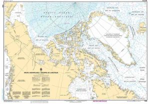
CHS CHART 7000: ARCTIC ARCHIPELAGO / ARCHIPEL DE LARCTIQUE
Edition Date: 16-Jan-2004
Paper Size: 49″ x 36″
Chart Image Size: 45⅜” x 31¾”
Scale: 1:5,000,000
All charts are printed up-to-date and corrected to the latest Notice to Mariners and meet commercial carriage requirements. Charts are printed on high-quality heavy paper with waterproof ink unless otherwise selected.